


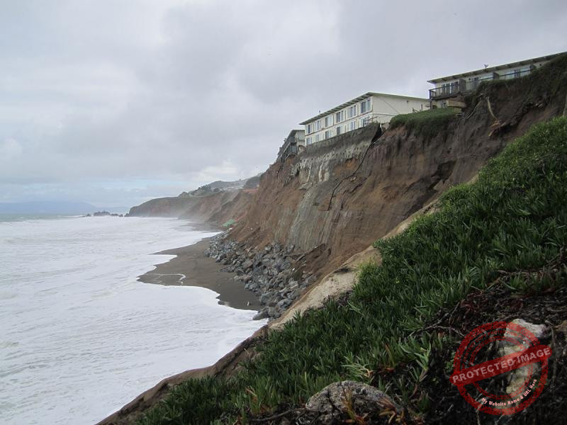
The National Centre for Coastal Research (NCCR), under the Ministry of Earth Sciences, has released an updated long‑term assessment of shoreline changes along the coastal districts of Valsad and Navsari in Gujarat, based on remote‑sensing analysis covering a 32‑year period from 1990 to 2022. The latest findings highlight sustained and significant erosion along both stretches of the state’s coastline. In Valsad, nearly 58% of the shoreline—36.62 km—has been classified as eroding at varying intensities, including 2.5 km under high erosion, 3.24 km under moderate erosion and 30.88 km experiencing low erosion. A similar pattern is observed in Navsari, where 60% of the coastline, or 24.64 km, is affected. This includes 3.86 km of high erosion, 4.60 km of moderate erosion and 16.18 km falling under the low‑erosion category.
According to NCCR’s shoreline classification, the coastal stretch north of Udvada has been identified as a high‑erosion zone, while the Bhagal coastline has been placed in the moderate‑erosion category, both marking high‑risk areas. Other locations, including Govada, Dehri Beach, Umbergaon Beach, Nargol, Malwan Beach, Maroli, Kalgam Bariyawad Beach, Fansa, Umarsadi, Tithal and Kosamba, fall under the low‑erosion bracket. Although the Tithal region has been included in the long‑term assessment, NCCR has not recommended any coastal‑protection measures for this stretch. As part of its mandate, NCCR continues to study long‑term coastal processes, identify vulnerable zones and advise coastal States and Union Territories on mitigation strategies, while the responsibility for implementing protective measures rests with the respective governments.
To enhance national efforts toward managing coastal and riverbank erosion, the Government of India issued revised guidelines on June 20, 2024, for appraisal and release of funds under the National Disaster Management Fund. These guidelines, aligned with the recommendations of the 15th Finance Commission, facilitate financial support for erosion‑mitigation works through NDMF and allow resettlement of impacted populations under the National Disaster Relief Fund, with an allocation of ₹1,500 crore for the 2021–26 period.
Broader national assessments show that about 33.6% of India’s 7,500‑km coastline is vulnerable to erosion, with the east coast—particularly West Bengal—experiencing the highest rates of land loss.
Shoreline‑change data from 1990 to 2018 indicates that 33.6% of the coast has eroded, 26.9% has gained land through accretion and 39.6% remains stable. State‑wise data shows that more than 60% of West Bengal’s coastline experienced erosion over the 28‑year period, followed by Puducherry with 56.2%. Kerala and Tamil Nadu recorded erosion along 46.4% and 42.7% of their coastlines respectively.
The proportion of eroded coastline stood at 34.6% in Daman & Diu, 28.7% in Andhra Pradesh, 27.6% in Gujarat, 25.6% in Odisha, 25.5% in Maharashtra, 23.7% in Goa and 19.2% in Karnataka.
In contrast, Odisha recorded the highest share of accretion at nearly 51%, followed by Andhra Pradesh with 49.6%. Accretion was also observed along the coastlines of Karnataka (26.2%), West Bengal (25.2%), Tamil Nadu (23.8%), Kerala (22.8%), Gujarat (19.4%), Goa (13.7%), Daman & Diu (11.7%), Puducherry (10.6%) and Maharashtra (10%). More than half of the coastline along most west‑coast states and Union Territories remained stable during the study period, except in Kerala, while stability levels on the east coast ranged from 14.3% in West Bengal to around one‑third in Tamil Nadu and Puducherry.
Overall, the data confirms that the west coast is more stable than the east coast. Of the west coast’s 3,762.62‑km stretch, 1,113.27 km—about 30%—experienced erosion, while the east coast saw 1,205.4 km of erosion along its 3,144.56‑km length, accounting for 38%.
Accretion occurred along 690.5 km of the west coast and 1,164.5 km of the east coast, representing 18% and 37% of their respective coastlines. Except for Karnataka on the west coast and Andhra Pradesh and Odisha on the east coast, accreted stretches were significantly smaller in extent compared with eroded areas across all other coastal States and Union Territories.
Experts attribute these patterns to a combination of natural and human‑induced factors, including rising sea levels, intensified cyclonic activity, mangrove loss, sand mining, dredging and upstream dam construction. The predominantly sandy terrain of the east coast makes it more erosion‑prone compared with the relatively rocky west coast. NCCR continues to rely on satellite‑based monitoring for shoreline analysis, while several states have undertaken structural measures such as sea walls, groynes and breakwaters, along with nature‑based interventions like strengthening mangrove belts and coastal vegetation to enhance long‑term resilience.


